ข้อมูลความลึกพื้นทะเลชุดใหม่ในอ่าวไทย และทะเลอันดามันในเขตประเทศไทย
Main Article Content
Abstract
Pachoenchoke Jintasaeranee and Chantima Piyapong
รับบทความ: 20 กุมภาพันธ์ 2565; แก้ไขบทความ: 31 มีนาคม 2565; ยอมรับตีพิมพ์: 27 พฤษภาคม 2565; ตีพิมพ์ออนไลน์: 30 พฤศจิกายน 2565
บทคัดย่อ
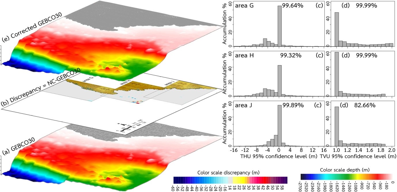
งานวิจัยนี้มีวัตถุประสงค์เพื่อตรวจสอบความคลาดเคลื่อนและปรับแก้ความถูกต้องข้อมูลความลึก GEBCO30 ชุดใหม่ เผยแพร่เมื่อ ค.ศ. 2015 จาก 6 พื้นที่ศึกษาบริเวณอ่าวไทย และ 3 พื้นที่ศึกษาบริเวณทะเลอันดามันในเขตประเทศไทย โดยเปรียบเทียบกับข้อมูลหยั่งน้ำชุดล่าสุดของกองสร้างแผนที่ กรมอุทกศาสตร์ กองทัพเรือ เผยแพร่เมื่อ พ.ศ. 2562 จำนวนรวมทั้งสิ้น 75 ระวาง ผลการศึกษาข้อมูลความลึก GEBCO30 ในพื้นที่ศึกษาบริเวณอ่าวไทยมีค่าความคลาดเคลื่อน THU 95% confidence level มากที่สุดร้อยละ 99.97 ที่พื้นที่อ่าวไทยด้านทิศใต้ (area F) และค่าน้อยที่สุดร้อยละ 99.84 ที่พื้นที่อ่าวไทยฝั่งตะวันออก (area A) และพื้นที่ศึกษาในทะเลอันดามันในเขตประเทศไทยมีความคลาดเคลื่อน THU 95% confidence level มากที่สุดร้อยละ 99.89 ที่ด้านล่างของพื้นที่ศึกษา (area J) และน้อยที่สุดร้อยละ 99.32 ที่ตอนกลางของพื้นที่ศึกษา (area H) แสดงว่าความคลาดเคลื่อนมีค่ามากกว่าบริเวณพื้นที่ค่อนข้างราบเรียบ ข้อมูล GEBCO30 ที่ถูกปรับแก้ความถูกต้องแล้วในพื้นที่ศึกษาทั้งหมดมีค่า TVU 95% confidence level มากที่สุดร้อยละ 99.99 เกือบทุกพื้นที่ ยกเว้นที่ area J ที่พบค่าเพียงร้อยละ 82.66 ข้อมูล GEBCO30 ที่ถูกปรับแก้ความถูกต้องแล้วรวมกับข้อมูล GEBCO30 ในบริเวณอ่าวไทยพบว่ามีค่า SD ต่ำกว่าร้อยละ 1 ของความลึกน้ำ ในขณะที่ข้อมูล GEBCO30 ที่ถูกปรับแก้ความถูกต้องแล้วรวมกับข้อมูล GEBCO30 ในทะเลอันดามันในเขตประเทศไทยมีค่า SD ใกล้เคียงกับร้อยละ 1 ของความลึก ข้อมูลความลึกชุดใหม่นี้อาจนำไปใช้ในการอธิบายลักษณะพื้นทะเลบริเวณอ่าวไทยและทะเลอันดามันในเขตประเทศไทยเพื่อการตัดสินใจวางแผนสำรวจและวิจัย
คำสำคัญ: อ่าวไทย ทะเลอันดามัน ภูมิศาสตร์พื้นทะเล ข้อมูลความลึกเชิงพื้นที่
Abstract
This research aimed to examine discrepancy and correct new GEBCO30 bathymetric data that was published in 2015 from 6 study areas in the Gulf of Thailand and 3 study areas in the Andaman Sea in the area of Thailand by comparison with the present ship–line sounding data of the Hydrographic Department, the Royal Thai Navy that were published in 2019 for 75 Navigation Charts in total. The results which were the study areas in the Gulf of Thailand had a maximum value of THU 95% confidence level of 99.97% at the area at the South (area F) and a minimum value of 99.84% at the area at the East (area A) and the study in the Andaman Sea in the area of Thailand had a maximum value of THU 95% confidence level of 99.89% at the lower part of the study areas (area J) and a minimum value of 99.32% at the middle part of the study areas (area H) showed higher values of discrepancy at almost smooth areas. The corrected GEBCO30 data of most study areas had a value of TVU 95% confidence level of 99.99% except at area J had a value of 82.66%. The collected GEBCO30 data plus the GEBCO30 data in the Gulf of Thailand showed SD value below 1% of water depth, while the collected GEBCO30 bathymetric data plus GEBCO30 data in the Andaman Sea in the area of Thailand showed a value of SD close to 1% of water depth. The new bathymetric data may be used for describing seafloor morphology of the Gulf of Thailand and the Andaman Sea in the area of Thailand for decision making to plan a survey and conduct a research.
Keywords: The Gulf of Thailand, Andaman Sea, Bathymetry, Qualitative bathymetric data
Downloads
Article Details

This work is licensed under a Creative Commons Attribution-NonCommercial 4.0 International License.
References
Beyer, A., Rathlau, R., and Schenke, H. W. (2005). Multibeam bathymetry of the Hakon Mosby mud volcano. Marine Geophysical Researches 26: 61–75.
Beyer, A., Schenke, H. W., Klenke, M., and Nie-derjasper, F. (2003). High resolution bathymetry of the eastern slope of the Porcupine Seabight. Marine Geology 198: 27–54.
Hydrographic Department. (2019). Nautical Charts and Publications. Navigational Supporting Center. Hydrographic Department. Royal Thai Navy. Retrieved from http://www.navigationsupport.com/, November 16, 2020.
IHO S–44. (2008). IHO Standards for Hydrographic Surveys: 5th ed. February 2008, Special Publication No. 44, International Hydrographic Organization. Monaco: International Hydrographic Bureau.
Jintasaeranee, P. (2013). A preliminary study on a discrepancy of the bathymetric data in the Gulf of Thailand. Burapha Science Journal 18(2): 97–106. (in Thai)
Jintasaeranee, P. (2018). A high resolution bathymetric data for the inner Gulf of Thailand. Burapha Science Journal 23(3): 1559–1570. (in Thai)
Jintasaeranee, P., and Buranapratheprat, A. (2017). A correction of the general bathymetric data in the Gulf of Thailand. Bura-pha Science Journal 22(2): 118–134. (in Thai)
Jintasaeranee, P., Intacharoen, P., and Buranapratheprat, A. (2018). A correction of the GEBCO30 bathymetric data in the Andaman Sea. Burapha Science Journal 23(3): 1538–1548. (in Thai)
Marks, K. M., and Smith, W. H. F. (2005). 2500m isobath from satellite bathymetry: Accuracy assessment in light of IHO S–44 standards. International Hydrographic Review. 6(2): 1–11.
Sandwell, D. T., Smith, W. H. F., Gille, S., Kapel, E., Jayne, S., Soofi, K., Coakley, B., and Geli, L. (2006). Bathymetry from space: Rationale and requirements for a new, high–resolution altimetric mission. Comptes Rendus Geoscience 338: 1049–1062.
The GEBCO_08 Grid. (2010). Version 20100927. Retrieved from http://www.gebco.net, May 16, 2011.
The GEBCO_2014 Grid. (2015). Version 20150318. Retrieved from http://www.gebco.net, November 8, 2016.
Wessel, P., and Smith, W. H. F. (1998). New improved version of generic mapping tools release. EOS Transactions American Geophysical Union 79(47): 579.
